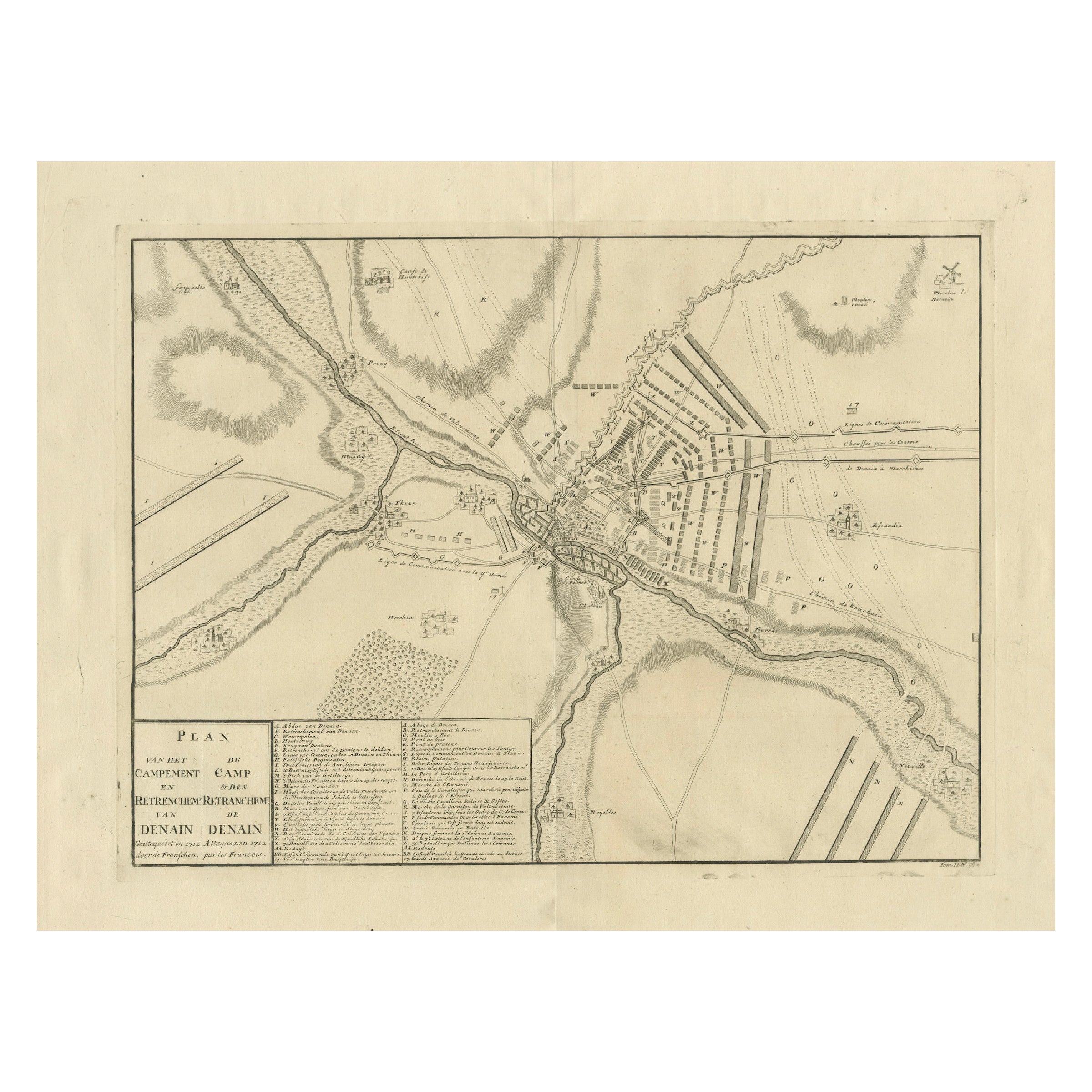
Detailed 1729 Battle Map – Allied Army Camp at Denain France, 1712 Siege
€ 450
Original antique · The actual sheet photographed · Certificate of authenticity on request · Sold unframed · Worldwide shipping from € 15 (rates)
Date
1729
Sheet size
53 × 59 cm (20.9 × 23.2 in)
Condition
Good
Reference
BG-13201-1
What the condition grades mean
Excellent
Bright and clean, with no faults worth mentioning.
Very good
Only light signs of age, such as faint toning.
Good
Normal signs of age for a sheet of this period: toning, some foxing, small marks or neat old repairs.
Fair
Clear faults such as staining, tears or repairs, priced to match.
Every fault we see is written in the condition note, and the whole sheet is shown uncropped in the photos.
Condition
Very good condition. Strong impression with clear details. Light general age toning and minimal scattered foxing, mainly outside the printed area. Original center fold as issued. Wide margins with slight handling wear at edges.
About this sheet
Map of Allied Camp at Denain, France, 1712 Attack – Published 1729
This engraved map depicts the army camp of the Allied forces at Denain, attacked by the French on July 24, 1712 during the War of the Spanish Succession. The title reads: Plan van het Campement en de Retrenchmenten der Geallieerden by Denain, meaning Plan of the Camp and Retrenchments of the Allies at Denain. It was published in 1729 as part of the second volume of the Dutch edition of Jean du Mont’s Krygs-overgeschiedenissen (Military Histories), under Tom. II. No. 58\*. This large, detailed plan illustrates the positions of regiments, entrenchments, artillery placements, river crossings, and the layout of the fortified camp. The legend below provides an extensive key identifying over 30 different features, including headquarters of Prince Eugene of Savoy and various lines of defense.
The Battle of Denain was a decisive engagement where French forces under Marshal Villars defeated the Allies, reversing their earlier successes and leading to the Treaty of Utrecht in 1713. This map reflects the strategic complexity of early 18th-century warfare, with detailed troop arrangements and fortifications. Such maps were used for both military education and historical record, and are now valued for their historical significance and decorative appeal.
The engraving was likely produced by Leonard Schenk or Pieter Schenk in Amsterdam, known for publishing military maps and atlases. The clear linework and detailed layout are characteristic of their workshop.
Condition report:
Very good condition. Strong impression with clear details. Light general age toning and minimal scattered foxing, mainly outside the printed area. Original center fold as issued. Wide margins with slight handling wear at edges.
Framing suggestion:
Frame with a simple dark wood or black frame and an archival cream or off-white mat to highlight the engraving. Use UV-protective glass to preserve the paper and avoid further toning.