Maps & PrintsBartele Gallery · Langweer
Home / Antique Maps / Africa

Africa · 17th century

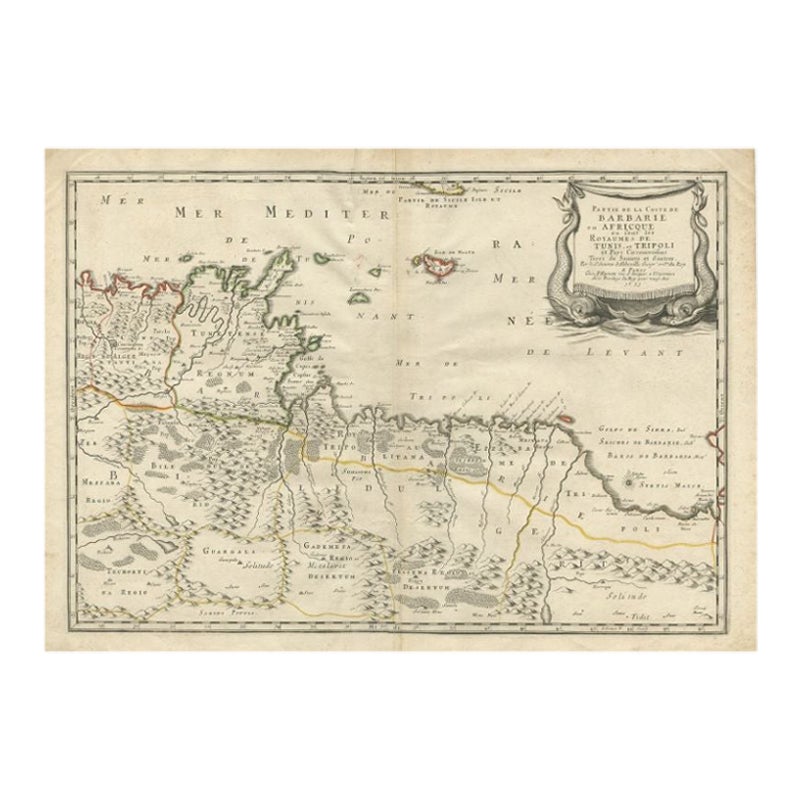
Rare Antique Map of 'Barbarie' or Northern Africa, 1655

€ 172

Original antique · The actual sheet photographed · Certificate of authenticity on request · Sold unframed · Worldwide shipping from € 15 (rates)

Date
1655
Mapmaker / artist
Nicholas Sanson d'Abbeville (1600 - 1667) and his descendents were important French cartographer's active through the 17th century. Sanson started his career as
Sheet size
43 × 59.5 cm (16.9 × 23.4 in)
Condition
Good
Reference
BG-00817
What the condition grades mean
Excellent
Bright and clean, with no faults worth mentioning.
Very good
Only light signs of age, such as faint toning.
Good
Normal signs of age for a sheet of this period: toning, some foxing, small marks or neat old repairs.
Fair
Clear faults such as staining, tears or repairs, priced to match.

Every fault we see is written in the condition note, and the whole sheet is shown uncropped in the photos.

Condition

General age-related toning, minor defects from handling. Please review the images for further condition details.

About this sheet

Antique map titled 'Partie de la Coste de Barbarie en Africque ou sont les Royaumes de Tunis et Tripoli et Pays Circomvoisins'. This map depicts North Africa with Malta and originates from 'Cartes generales de la Geographie ancienne et nouvelle', Paris, 1655. Artists and Engravers: Nicholas Sanson d'Abbeville (1600 - 1667) and his descendents were important French cartographer's active through the 17th century. Sanson started his career as a historian where, it is said, he turned to cartography as a way to illustrate his historical studies. In the course of his research some of his fine maps came to the attention of King Louis XIII who, admiring the quality of his work, appointed Sanson 'Geographe Ordinaire du Roi'. Sanson's duties in this coved position included advising the King on matters of Geography and compiling the royal cartographic archive. Sanson's corpus of some three hundred maps initiated the golden age of French Cartography.

Condition: Good, General age-related toning, minor defects from handling. Please study image carefully.
Date: 1655
Overall size: 59.5 x 43 cm.
Image size: 54 x 37.5 cm.

They were the product of engraved, etched or lithographed plates. These plates were handmade out of wood or metal, which required an incredible level of skill, patience and craftsmanship. Whether you have a house with Victorian furniture or more contemporary decor an old engraving can enhance your living space.

More from Africa

Ask about this sheet

Rare Antique Map of 'Barbarie' or Northern Africa, 1655
1655 · Ref. BG-00817 · € 172
We reply by email, usually within one working day.

Your favorites

Saved in this browser. Email the list to yourself to keep it on any device.

We use your email to send this list and, only if you tick the box and confirm, for occasional new arrivals. Every email has an unsubscribe link. Bartele Gallery, the Netherlands.