About this sheet
Vintage Paris Metro Map, Ligne 11 Opening, Art Deco Transit Plan 1935
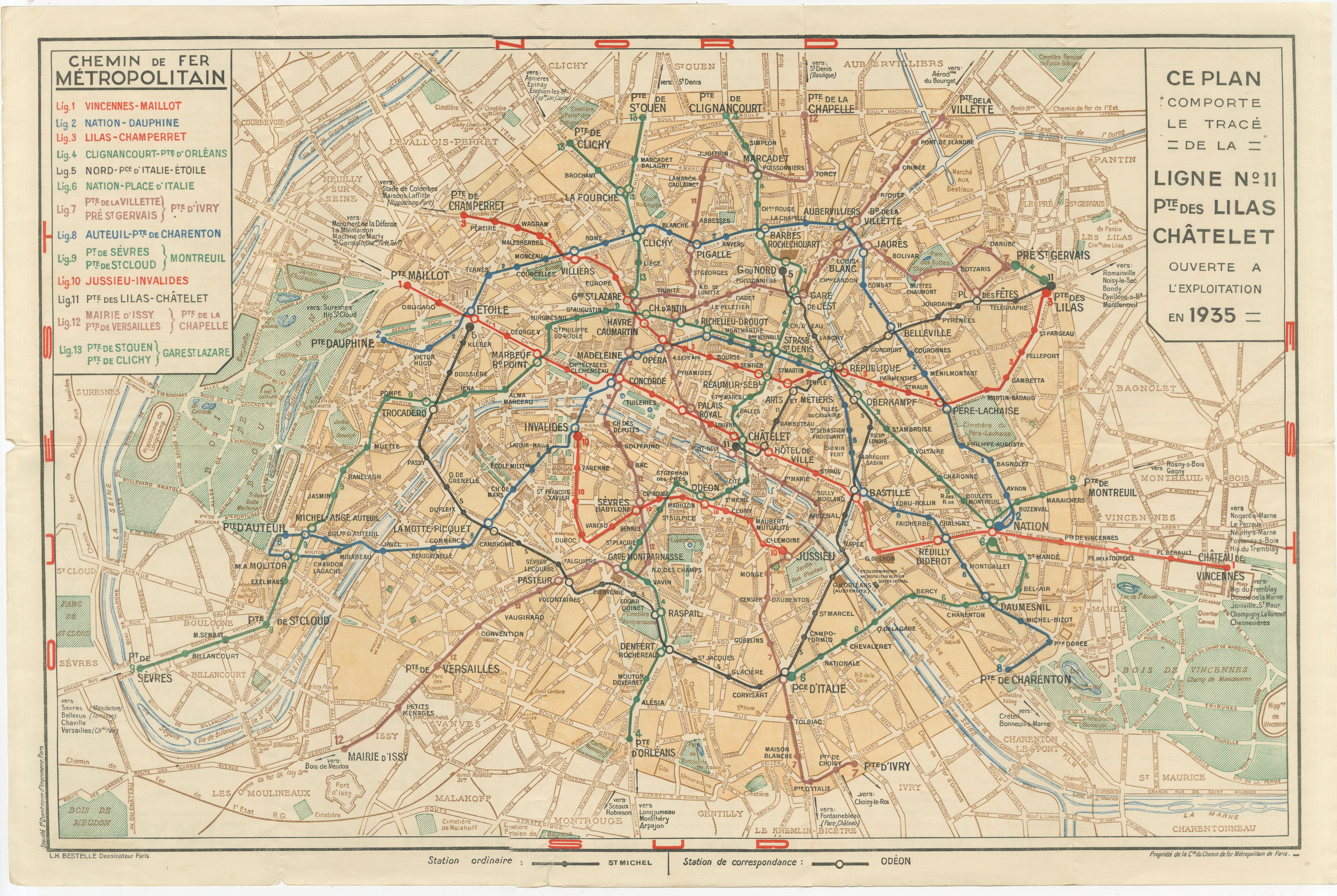
A striking and highly decorative original 1930s map of the Paris Métropolitain, issued during a key moment in the expansion of the city’s underground network. This example prominently highlights the opening of Ligne No. 11 between Châtelet and Porte des Lilas, inaugurated in 1935, placing the map firmly within the dynamic interwar period when Paris was rapidly modernizing its infrastructure.
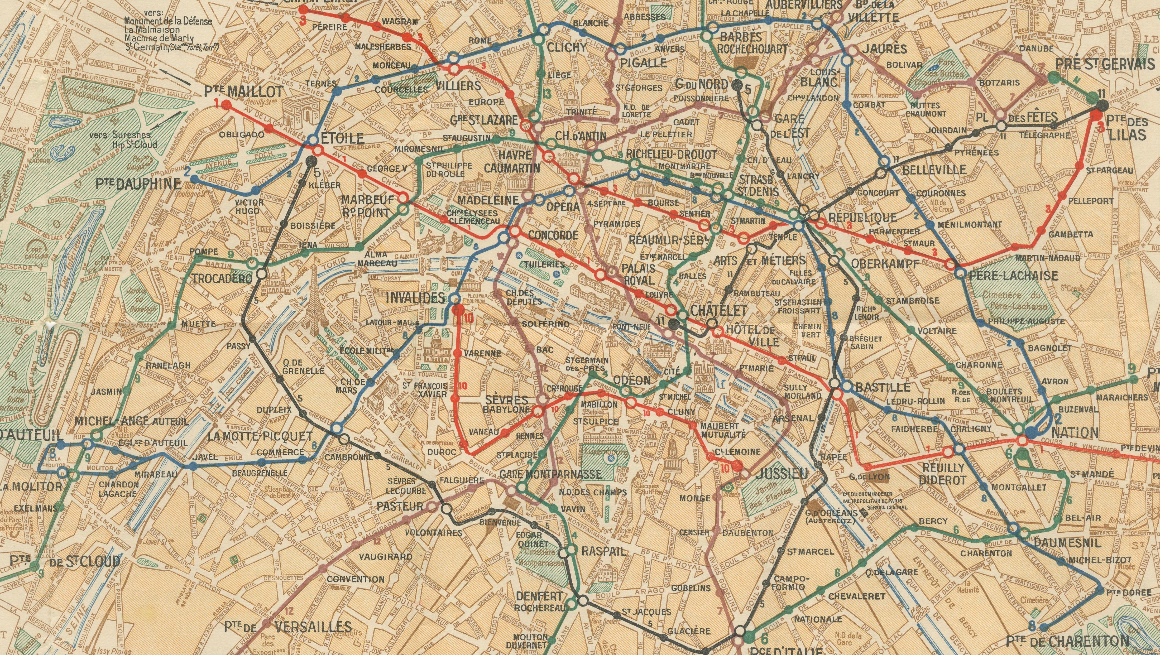
The map presents the métro system over a detailed geographical plan of Paris and its surrounding suburbs, offering both clarity and visual richness. Color-coded lines run elegantly across the city, linking major districts such as Opéra, Bastille, Montmartre, and the Latin Quarter, while extending outward toward Vincennes, Boulogne, Issy, and Saint-Ouen. The combination of a functioning transport diagram with a full street layout gives this piece a distinctive dual character—both practical and highly decorative.
A strong visual feature is the right-hand panel announcing the opening of Line 11, which adds historical context and a focal point that enhances its appeal. The design reflects the clean and efficient graphic style of the 1930s, subtly influenced by Art Deco aesthetics, while remaining highly legible and structured. Produced by the Compagnie du Chemin de Fer Métropolitain de Paris, this map captures the network at a moment before its later expansion into the modern system.
Today, this piece stands as a refined visual document of Paris between the wars, offering insight into urban planning, mobility, and the cultural identity of the city. It is both a collectible historical artifact and a strong decorative statement, ideal for interiors with a Parisian, architectural, or modern classic aesthetic.
Interchange station Interchange
Ordinary station Station ordinaire Station de correspondance
Lines List:
Line 1: Vincennes – Maillot
Line 2: Nation – Dauphine
Line 3: Lilas – Champerret
Line 4: Clignancourt – Orléans
Line 5: Nord – Place d’Italie – Étoile
Line 6: Nation – Place d’Italie
Line 7: Porte de la Villette – Ivry / Pré-Saint-Gervais – Porte de la Villette
Line 8: Auteuil – Porte de Charenton
Line 9: Porte de Sèvres – Porte de Montreuil
Line 10: Jussieu – Invalides
Line 11: Porte des Lilas – Châtelet
Line 12: Mairie d’Issy – Versailles
Line 13: Porte de la Chapelle – Chapelle
Line 14: Porte de Saint-Ouen – Gare Saint-Lazare
Line 15: Porte de Clichy – Clichy
Condition: Good overall condition with light age-related toning and minor wear to folds and edges. Colors remain fresh and well preserved. Please study the image carefully.
Framing tips: This piece works exceptionally well in a thin black or dark bronze frame with a wide ivory mat, enhancing its graphic clarity. Ideal for a modern interior, Paris-themed setting, or as part of a curated wall of city plans.
This is an original 1930s lithograph, not a reproduction. All items we offer are authentic period works of art. The map is sold unframed; any framed images are shown for presentation and interior inspiration only.
Keywords: Paris Metro map, Paris Métropolitain, Ligne 11, Châtelet, Porte des Lilas, 1935, Art Deco map, vintage Paris plan, subway map Paris, French transport history, interwar Paris, Paris city map, decorative map, urban planning, Paris infrastructure, metro lines Paris, Paris transport map, antique Paris print, Paris subway diagram, Paris street map, French railway map, Paris wall art, city plan Paris, historic Paris map, Paris decor, European city map, vintage transit map, Paris architecture, Montmartre, Bastille, Opéra, Latin Quarter, Vincennes, Boulogne, Issy, Saint-Ouen, Châtelet Les Halles, Gare Saint-Lazare, Gare du Nord, Gare de Lyon, Paris landmarks, metropolitan railway Paris
Technique: Lithograph
Maker: Compagnie du Chemin de Fer Métropolitain de Paris, Paris, circa 1935